THIS WEEK’S FEATURED WALKS:

ALL TRAILS

ETHEROW TO WERNETH LOW WALK
Tick off two popular Greater Manchester landmarks in this one circular walk that’s perfect to time with sunset
Start: Marple Train Station, Brabyns Brow, Stockport, SK6 7DA
Distance: 9.7 miles
Elevation: 950 feet
Duration: 4 hours
Difficulty: Moderate
Navigation: Follow step-by-step on komoot, or download GPX file
About the route
This nine mile pub walk truly has it all: a cracking pub, unreal views across Manchester, and my favourite place in Stockport to sit and watch the world go by (the Keg Pool at Etherow Country Park).
The walk takes you to a stunning pub with views right across Manchester — and yntil the end of October, you can grab a ~free~ breakfast here just by completing a walk nearby.
To claim your free breakfast, simply show that you’ve completed a local walking route to a member of the team. The offer is also available across all Chef & Brewer Collection pubs around the country,
Route highlights
Hare & Hounds
No long walk is complete without a proper pub, and this one on top of Werneth Low is my all time favourite in Greater Manchester. With views stretching across Manchester, it’s perfect time to time with a sunset walk.
And until the end of October 2024, you can get a free breakfast at this Chef & Brewer pub just by completing a walk nearby. All you need to do to claim your free breakfast is show a completed All Trails route to a member of staff, or simply show the step count on your smart phone or watch. The promotion is valid across all participating Chef & Brewer Collection pubs throughout October.
Tip: save a trip here for Bonfire Night and watch the fireworks all across Manchester.
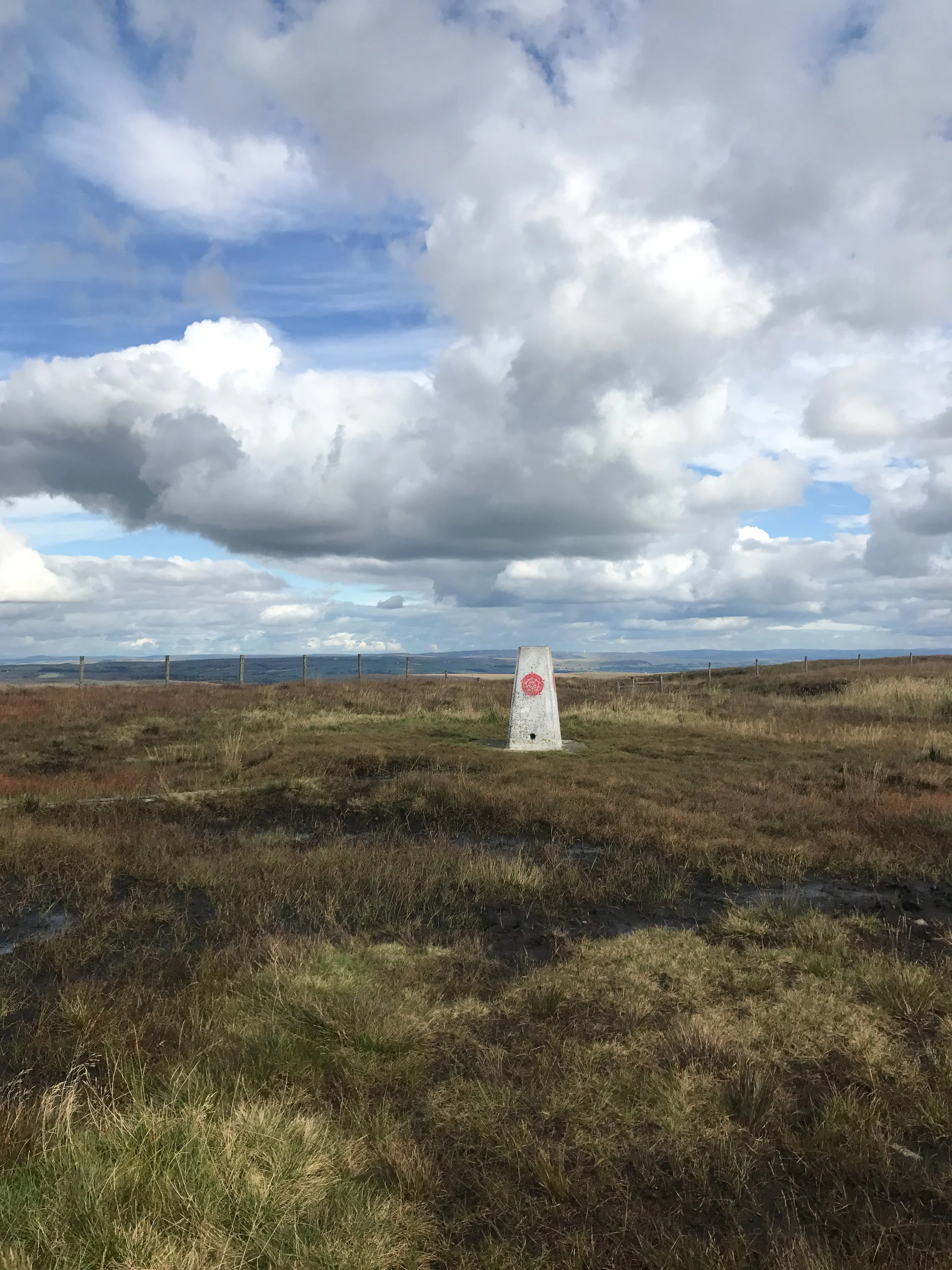
Werneth Low
Werneth Low, just outside Manchester, is a well-loved spot for locals looking to enjoy beautiful countryside walks with sweeping views of the city and beyond. Having grown up just down the road, it’s long been my favourite ‘clear your head’ spot. Nothing else seems to matter when you have sweeping views across the city, a cracking pub, and plenty of trails to choose from once you’ve got your fill of view soaking.
If you're following this specific route, Werneth Low marks the halfway point—an ideal spot to pause, take in the stunning views, and recharge at the pub before starting the descent back to Marple.
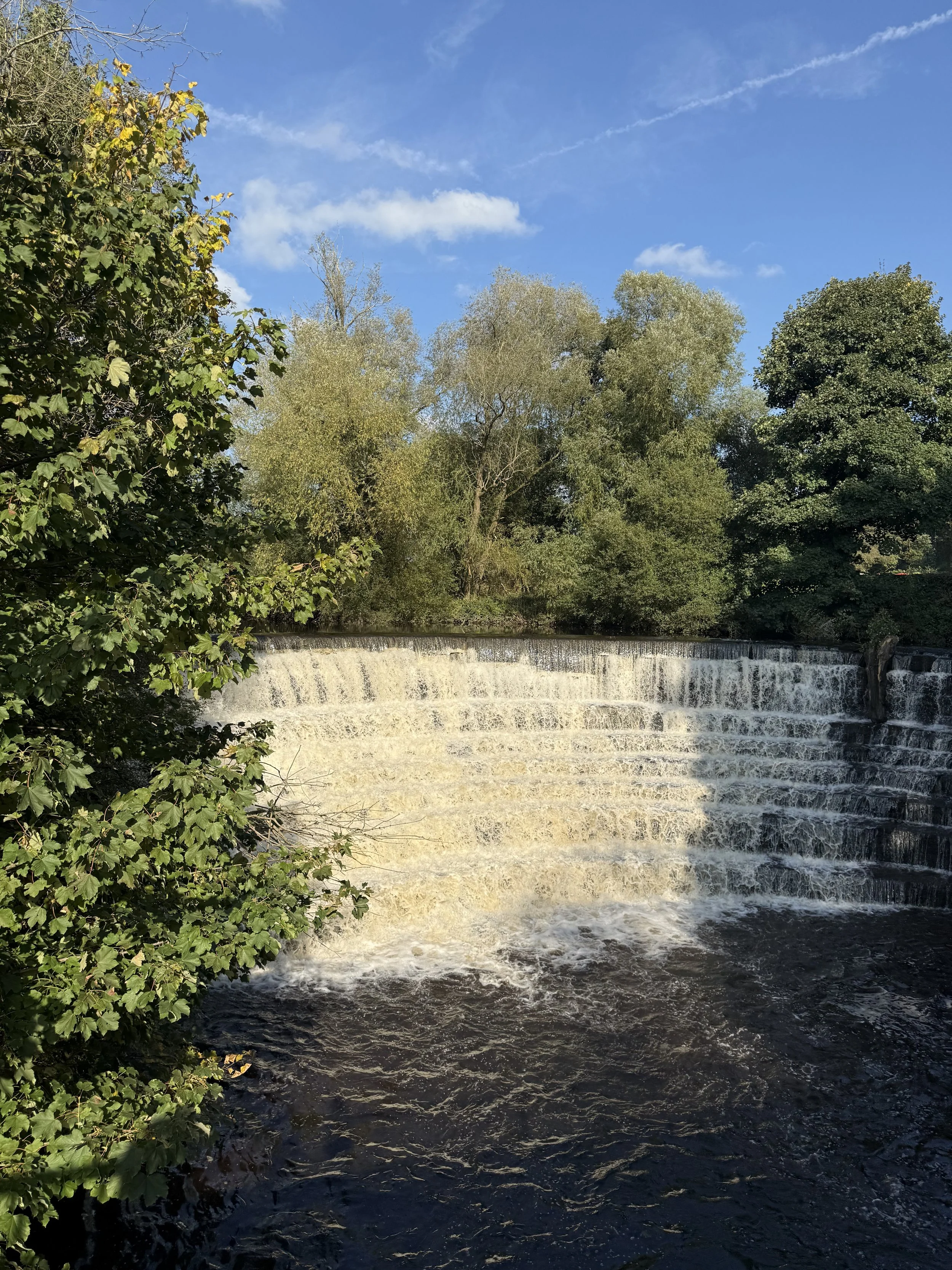
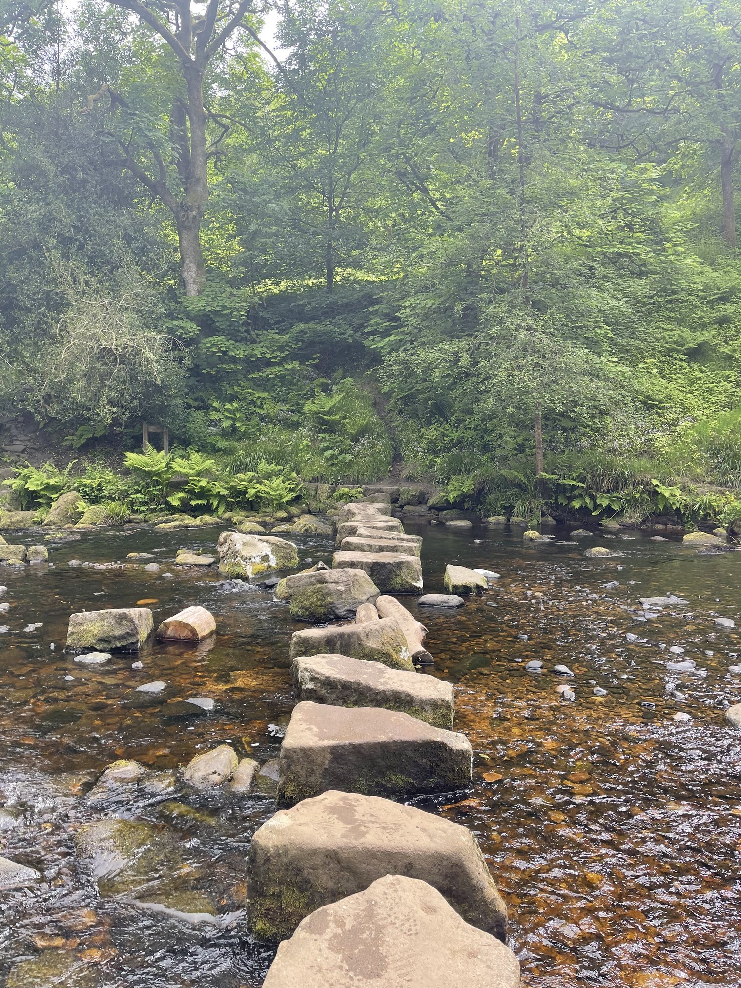
Etherow Country Park
Etherow Country Park, located near Compstall in Greater Manchester, is a fantastic spot for outdoor activities, offering a range of facilities for visitors. At its heart is a large lake, perfect for a leisurely walk, and there's even a sailing club for thosethat fancy a day on the water. The park also has a café, picnic areas, and a visitor center that provides information about the local wildlife and history.
One of the key highlights of Etherow is how well it links up with other long-distance footpaths. It's a starting point for the Goyt Way, which forms part of the larger Midshires Way, taking walkers on scenic routes through the countryside. From the park, you can also connect to the Peak Forest Canal and explore further into the Peak District on its doorstep.
My favourite place here is Etherow’s Keg Pool, a pleasant lakeside path which takes you away from the hustle and bustle at the start of the park. Etherow Country Park is a great spot to explore year-round, but if you visit in late spring or early summer, you may even be lucky enough to spot cygnets —baby swans— on the lake. Swans usually lay their eggs in April or May, and the cygnets hatch after about five to six weeks, typically around late May or June.
Marple aqueduct
Marple Aqueduct is an impressive highlight along your walk, showcasing stunning engineering as it carries the Peak Forest Canal over the River Goyt. At 100 feet high, it’s one of the tallest aqueducts in Britain, offering breathtaking views over the river valley and the surrounding countryside.
As you approach the aqueduct, you'll also find it links seamlessly with several popular trails, including the Cheshire Ring canal route, the Middlewood Way, and the Goyt Way.

Where is Werneth Low?
Werneth Low is a beautiful hilltop just outside Hyde in Greater Manchester, sitting right on the border between Tameside and Stockport. It’s part of the Pennine foothills, and if you make it to the top, you’re rewarded with incredible panoramic views. On a clear day, you can see right across Manchester, over Cheshire, and even catch glimpses of North Wales.
The hill is a popular spot for locals and visitors alike, perfect for a relaxing walk, a scenic cycle, or even a peaceful picnic. It’s also home to the Hyde War Memorial at the summit, serving as a poignant reminder of the area's past.
Don’t fancy the walk up from Marple? There’s a car park at the pub so you can still take in those stunning views, without the extra legwork.
Getting to the starting point
Arriving by car
We parked at Marple Train Station, with free all day parking. You also have your pick of starting points on this route, with ample parking in Romiley, Etherow Country Park or Werneth Low.
Public transport
You have multiple transport options to choose from on this route. You can catch the train from Manchester to Marple, Romiley, or get the 330 close to Werneth Low in Hyde. This walk starts in Marple, but can easily be picked up by starting at Romiley train station with no extra mileage if this option is easier for you.
✔️ Good to knows
Facilities: Car park, toilets (Etherow), cafe (Etherow)
Sunset variation: Werneth Low is a great place to watch the sun set over Manchester. You can easily shorten this route to just include Werneth Low if you’re wanting to head here for sunset. Simply park at Werneth Low Country Park and it’s just a short walk to the summit.
Hare & Hounds: A stunning Chef & Brewer pub with views right across Manchester
🧭 Following the route
I use komoot and OS Maps for offline navigation. To follow this walk step-by-step on komoot, simply click this link here or download the GPX file and upload it to your chosen app, such as OS Maps.
Fancy giving this one ago? Check out our full guide on Instagram
More routes like this one:

BAMFORD AND STANAGE EDGE WALK
Tick off two popular Peak District viewpoints in this one circular walk that’s perfect to time with sunrise

Start: Heatherdene Car Park, S33 0BY
Distance: 7 miles
Elevation: 1,150 feet
Duration: 3 hours
Difficulty: Moderate
Navigation: Follow step-by-step on komoot, or download GPX file
Route highlights
Bamford Moor
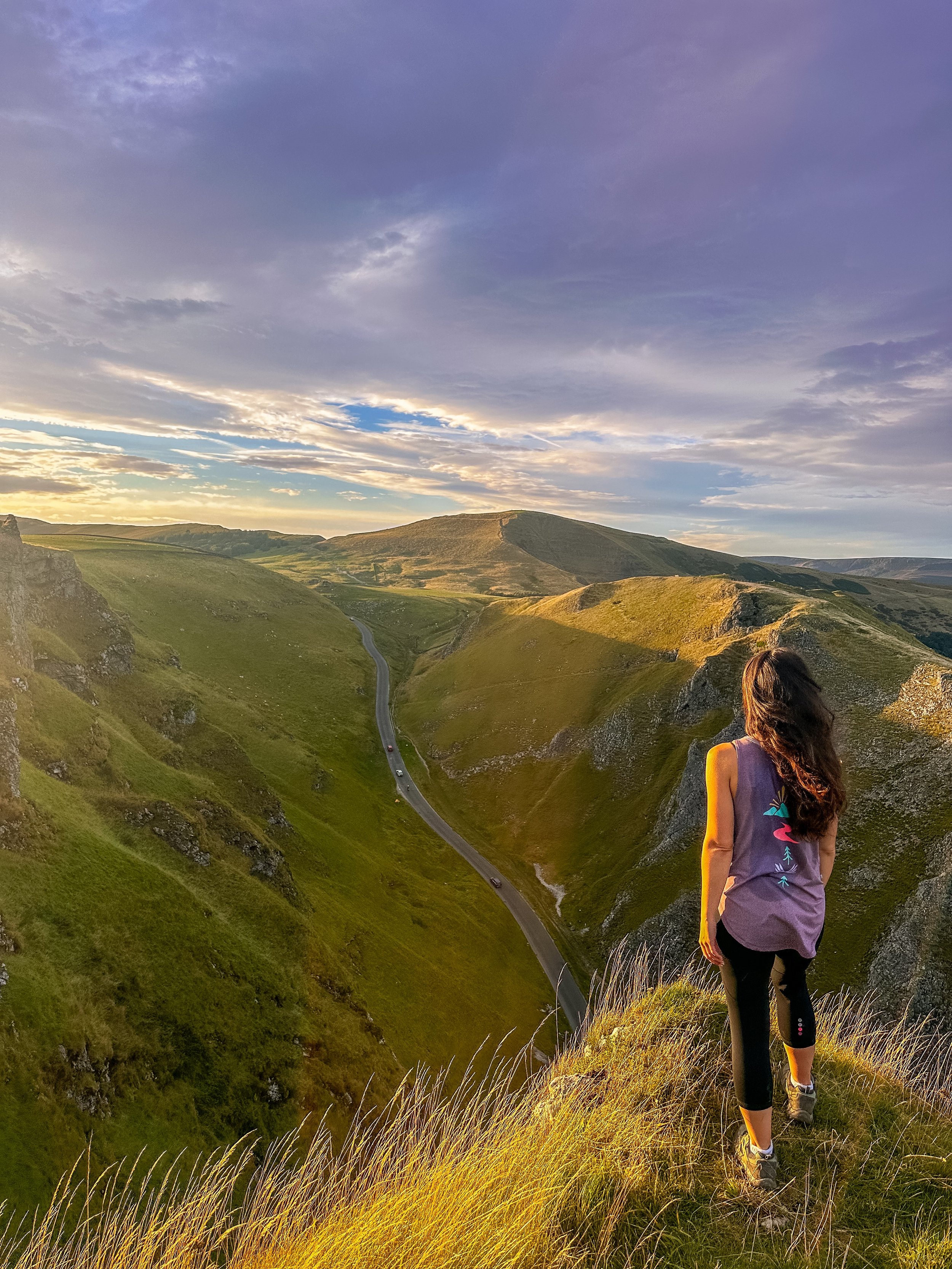
Bamford Moor, accessible from Heatherdene, offers rugged landscapes, vibrant heather, and sweeping views of the Derwent Valley. It features babbling brooks and a Bronze Age stone circle, making it a fascinating mix of natural beauty and history.
Stanage Edge
Stretching across four miles, Stanage Edge is a renowned gritstone escarpment north of Hathersage, with panoramic views of the Dark Peak moorlands and Hope Valley. This popular walking and climbing destination gained fame after appearing in the 2005 film 'Pride & Prejudice'.
Bamford Edge
Bamford Edge, a prominent gritstone overhang in the Peak District, is perfect for catching a spectacular sunrise over Ladybower Reservoir, Win Hill, and Hope Valley from its 1,381-foot summit. Located near the village of Bamford, it is known for its distinct rock formations, including the photogenic 'Great Tor'.

Where is Bamford Edge?
Bamford Edge, located above the village of Bamford in the Peak District, offers stunning views of Ladybower Reservoir, the Hope Valley, and neighbouring peaks like Win Hill. It’s a fantastic spot for catching a cracking sunrise, with options to shorten the route and take in the 'Great Tor' rock formation — ideal for capturing that perfect shot.
Getting to the starting point
Arriving by car
We parked at Heatherdene Car Park close to Ladybower. During busy periods and weekends, the car park can fill up quickly — so it’s best to arrive early or visit mid-week.
Public transport
To reach Heatherdene Car Park by public transport, take the High Peak Bus 257 or TM Travel Bus 271/272 from Sheffield, or catch the train to Bamford Station with a short walk to the starting point.
Bus services are limited, so please check schedules ahead of time or consider walking from Bamford Station, which takes around 40-45 minutes.
✔️ Good to knows
Facilities are limited on this one. You’ll find public toilets available at the start of the walk (Heatherdene Car Park) and a cafe at nearby Derwent Reservoir if you’re looking to extend the route. Alternatively you can pair it with this Robin Hood’s Cave walk, and dip into Hathersage where you’ll find pubs and cafes aplenty after your hike.
Check the weather: The weather on top of Bamford Moor can be unpredictable. Pack layers and be prepared for changes in weather.
Arrive early: Heatherdeane Car Park gets incredibly crowded during the weekend, visit off-peak or by public transport where you can.
Sunrise variation: Looking for a shorter walk to catch sunrise? Check out our short Bamford Edge sunrise walk, clocking up just 3 miles.
Leave the trainers at home: The area around the moors can get incredibly boggy — so definitely bring your boots for this one.
Best time to visit: Early morning or late afternoon to avoid the crowds and catch the golden light.
Leave no trace: Help preserve the beauty of the Peaks. Leave the environment better than you found it and always stick to the paths.
🧭 Following the route
I use komoot and OS Maps for offline navigation. To follow this walk step-by-step on komoot, simply click this link here or download the GPX file and upload it to your chosen app, such as OS Maps.
Fancy giving this one ago? Check out our full guide on Instagram
More routes like this one:

MAGPIE MINE WALK
This scenic five mile circular walk is perfect to save for sunset — featuring a favourite Peak District photo stop

Start: White Lodge Pay and Display Car Park, DE45 1NL
Distance: 5 miles
Elevation: 624 feet
Duration: 2 hours
Difficulty: Easy-moderate
Navigation: Follow step-by-step on komoot, or download GPX file
About the route
This walk begins in at Deep Dale, crossing the River Wye before heading up to explore Magpie Mine. From here, you descend to the quiet village of Sheldon, heading through woodlands back to the car park.

Route difficulty
Walk type: Medium circular walk
Walk highlights: Ashford-in-the-Water, Magpie Mine, Deep Dale, Sheldon Village + River Wye
Stiles: There are several stiles on this route, each manageable if you have a smaller dog in tow. Otherwise please adjust the route accordingly.
Route highlights
Magpie Mine
Magpie Mine was used to mine lead for over 250 years and now you can explore the site on your walk — a perfect spot for photographers, too! The atmospheric remains of Magpie Mine make for one of the best places to visit in the Peak District, and one of the top industrial heritage sites in Derbyshire. It was the last working lead mine in the Derbyshire orefield and is one of the best surviving examples in the UK of a 19th century lead mine. The mine has a fascinating history spanning more than 200 years of bonanzas and failures, of bitter disputes and fights resulting in the murder of three miners, and a ‘Widow’s Curse’ that’s said to remain to this day.
Deep Dale
At the start of the walk, you’ll pass through Deep Dale — one of those special places where, if you visit the right part at the right time of year, you will see swathes of colour spreading over the hillsides. Nestled within the boundaries of the Peak District National Park, this grassland reserve has a rich cultural history including lead mining and the remains of a Romano-British settlement on a steep-sided hill called Fin Cop. Put simply, you’ll feel like you've stepped into a fairy tale — and its well-maintained trails make it easy for hikers of all levels to navigate.
Sheldon Village
The small village of Sheldon in the Derbyshire Peak District, perched high above the River Wye, is a real hidden gem. Surrounded by stunning White Peak limestone countryside, the village is a cluster of picturesque stone cottages on a hill, mostly built along one single lane. You’ll find a street lined with lovely stone cottages, and we even spotted a traditional red phone box, (now a defibrillator), as well as a pub called The Cock and Pullet.
The village bears the weight of history with its origins traced back to the Domesday Book of 1086. It rose to prominence in the 18th and 19th centuries, emerging as a vital hub for lead mining, a boom that swelled its population. Just beyond the village limits lies Magpie Mine, a remarkable testament to 18th-century lead mining and arguably one of the most complete sites of its kind in the entire Peak District, and perhaps even the UK.
The Cock and Pullet
Stepping out of the cold and into this charming pub complete with open fire was a real highlight of the walk. It was busy for midweek and most people were tucking into pub meals. If you do decide to visit, it’s open every day apart from Mondays. I think it’s important to support these remote country pubs to keep them thriving – the old saying ‘Use them or lose them’ rings true out here. The staff were incredibly friendly, and it was a great way to round off the walk before heading back to the car.

Where is Magpie Mine?
Magpie Mine is a historic lead mine located near the village of Sheldon in the Peak District, Derbyshire, just southwest of Bakewell.
Getting to the starting point
Arriving by car
We parked at White Lodge Car Park on the A6 between Buxton and Bakewell. Please note, during busy periods and weekends, the car park can fill up quickly — so it’s best to arrive early to get a space or visit mid-week.
You’ll also find roadside parking near Sheldon, but please keep well away from field access gates. Alternatively use the roadside car park giving access to Magpie Mine from the Bakewell to Buxton road.
Public transport
Catch the train to Buxton then take the TransPeak bus that goes between Buxton and Bakewell and stops in Ashford-in-the-Water near to the start of your walk.

✔️ Good to knows
Stiles: There are several stiles on this walk which may not be suitable for larger dogs.
Food and drink: You’ll pass wonderful country pub, The Cock and Pullet, which serves good food and has a wonderfully cosy atmosphere.
Parking: We parked at White Lodge Pay and Display Car Park (A6 between Bakewell and Buxton). Parking is £2.50 for 2 hours.
🧭 Following the route
I use komoot and OS Maps for offline navigation. To follow this walk step-by-step on komoot, simply click this link here or download the GPX file and upload it to your chosen app, such as OS Maps.
Fancy giving this one ago? Check out our full guide on Instagram
More routes like this one:

WINNATS PASS AND ODIN MINE WALK
A hidden gem of a walk taking in some of the best views across the Peak District
Start: Castleton Visitor Centre, S33 8WN
Distance: 5.02 miles
Elevation: 900 feet
Duration: 2 hours
Difficulty: Moderate
Navigation: Follow step-by-step on komoot, or download GPX file
About the route
This walk takes you high above Winnats Pass and around Castleton, meaning you can take in this amazing Peak District village from all angles. The start of the route leans towards the challenging side, taking you up a steep and rocky path straight up to Winnats Pass, so consider if this one’s for you before heading out. The first ascent is steep with scrambling required. Thankfully, a kind soul has left a climbers rope tied to a gate post which gives you all the leverage you need. We’ve been meaning to give this one a go for a while, and it didn’t disappoint.
Once atop Winnats Pass, you’ll follow a trail that leads close to the boundary wall and takes you along the top of the pass. Be sure to stop and take in the views on this part of the walk. We were blown away watching the tiny cars winding their way through the pass. From here, you’ll head along a footpath in the direction of Mam Tor, before taking a detour to Odin Mine: a disused mine thought to be in use since 1260. The landscape surrounding makes for great exploring, leading you to the collapsed road constructed beneath Mam Tor.
When you reach Treak Cliff Cavern, look out for signs that tell you about the history of the area. Winnats Pass and the surrounding environment was once under a tropical sea, making the site protected by law due to the many fossils of sea creatures which lived here over 350 million years ago.
The valley was created by melting glaciers which gradually dissolved, creating streams which flowed through and under cracks in the rock. One of these streams created a large underground cave system which eventually collapsed, leaving behind the Winnats Pass you see today.

Route difficulty
There are first section of this route is a tough descent with a rope in place to support you. This may sound off-putting to some, but it’s all part of the adventure — and well worth it for the epic views.
If the above doesn’t sound manageable to you, then this walk is easily adjustable (options below), yet still enjoy the best sections of the walk.
Adjusting the route
You can avoid the super steep incline at the beginning of the walk and by following the road the cars do. You’ll find a path alongside the road for walkers. We’ve done both on different occasions and while this is certainly an easier option, that doesn’t mean it’s not a little bit tough. The distance will also be roughly the same.
Route highlights
Winnats Pass
Visiting Winnats Pass walk is an absolute must if you’re heading to the Peak District National Park. The surrounds feel truly magical and the history of how it came to be is mind-blowing. While many people head here to admire the awe-inspiring landscape, little put the effort in to go one step further and hike along the two ridges that encapsulate the pass — and this is where the very best views can be found.
What is Winnats Pass?
Winnats Pass is a road that leads through the Peak District National Park with huge rugged hillsides on either side. It’s truly spectacular and has an impressive history; over 340 million years ago, the entire area was below the sea – Winnats Pass in particular is thought to have been a coral reef. Once you know this, it’s easy to believe this is true as the surfaces represent exactly that.
Odin’s Mine
Odin’s Mine, tucked away beneath Mam Tor, is one of England’s oldest known lead mines, with records dating back to the 13th century. Situated beneath the famous Mam Tor, it played a crucial role in the area’s mining heritage, supplying lead for everything from building to plumbing during medieval times. These days, it’s a fascinating spot for history buffs and outdoor lovers alike. Whether you’re exploring its atmospheric cave entrances or just soaking up the surrounding beauty, Odin’s Mine offers a unique window into Castleton’s industrial past.
Collapsed Road
The collapsed road near Castleton, often called "The Broken Road," is a fascinating spot that really shows off the power of nature. Running beneath Mam Tor, also known as the "Shivering Mountain" because of its shifting layers, this road was abandoned in the 1970s after constant landslides made it impossible to keep up. Now, the crumbled tarmac and dramatic surroundings attract plenty of walkers and photographers. It’s a great place to explore, offering not only a unique piece of history but also some breathtaking views of the Peak District’s rugged beauty.
Castleton
Once you’ve parked up in the picturesque village of Castleton, you’ll leave behind the quaint coffee shops and artisan ice-creams to find a long country road. You won’t need to follow this road for long before getting sight of the mystical Winnats Pass.

Where is Winnats Pass?
Winnats Pass is located in what’s known as the Hope Valley area of the Peak District National Park. It’s close to many other great walks in the area and is situated near the popular village of Castleton.
Getting to the starting point
Arriving by car
The Peak District National Park is made up of country roads, tiny villages and heaps of fields. The quickest and easiest way to get around is by car.
The trail begins in the nearby village of Castleton where you’ll find ample of places to park. We parked in Castleton Car Park. The postcode for this is S33 8WH and costs £2.50 for 2 hours, with the option to stay for longer if required.
Public transport
If you’re unable to drive or prefer to take public transport, then taking the bus is the best option since there isn’t a train station near the beginning of this walk. If you’re travelling to Manchester, take the train to Hope and catch the 62 bus to Castleton.

✔️ Good to knows
Winnats Pass: There are several routes up to Winnats Pass which don’t require the steep ascent with the climber’s rope. Decide if the steep ascent is for you before visiting and amend the route accordingly. You can do this easily using OS Maps or komoot.
Footwear: If you choose to follow our steeper route, definitley boot up for this one. You’ll need to navigate loose rock and uneven terrain on the ascent.
Food and drink: When you arrive back in the lovely little village of Castleton, you’ll be spoilt for choice when it comes to choosing somewhere to eat. You’ll be inundated with ice-cream options, cafes and some cracking pubs with excellent beer gardens, too. You canalso go back to basics and grab some fish and chips and sit by the river. Below are some of the locations we’ve tried and can recommend:
The George (pub)
Ye Old Nags Head (pub)
Rose Cottage (cafe)
Castleton Fish and Chips
Parking: We parked at Castleton Car Park (S33 8WH).
Public transport: Travelling from Manchester? Take the train from Manchester Piccadilly to Hope (48 mins), then either walk or catch the 62 bus to the starting point. Walking adds on 1.6 miles each way.
🧭 Following the route
I use komoot and OS Maps for offline navigation. To follow this walk step-by-step on komoot, simply click this link here or download the GPX file and upload it to your chosen app, such as OS Maps.
Fancy giving this one ago? Check out our full guide on Instagram
More routes like this one:

BLEAKLOW HEAD, B29 CRASH SITE AND LOWER SHELF STONES LOOP
A slightly more challening walk with incredible views across the Peak District moors

Start: Old Glossop, SK13 7RP
Distance: 9.4 miles
Duration: 4-4.5 hours
Elevation: 1,700 feet
Difficulty: Moderate
Navigation: Follow step-by-step on komoot, or download GPX file
About the route
If you like your walks to come with unreal views and plenty of trig bagging for good measure, this one’s for you. Starting and ending at a cracking pub in Old Glossop, this route takes you up to the popular B29 Crash Site before meandering to Higher Shelf Stones where you can catch a cracking sunset. This is a very popular area for hiking, wild camping, and running, so you'll likely encounter other people while exploring. Although, we visited on a Friday and didn’t bump into another soul for miles around. With most of the route taking you across the moors, this is a great place to visit during heather season.
On the return leg you’ll find a great wild camping spot, perfect for if you plan to extend the route and catch a sunrise the next day. Just remember to arrive late, leave early, and as always, leave no trace.
Route Highlights:
B-29 Superfortress Crash Site
On 3rd November 1948, a Boeing B-29 Superfortress (American bomber) called Overexposed crashed into the Peak District moorlands, near Higher Shelf Stones on Bleaklow. Part of the 16th Photographic Reconnaissance Squadron, used for military photography, the plane crashed due to a fatal navigation error in poor visibility. All thirteen crew members sadly lost their lives.
A tragic incident, but remarkable to see the remains left atop the moorland. Much of the wreckage remains on the moors as a memorial and an official plaque has been erected.
Bleaklow Head
This rugged moorland plateau offers a real sense of solitude and breathtaking panoramic views. Standing at 2,077 feet, Bleaklow is one of three summits on this plateau and is marked by a huge cairn. Expect incredible views over the peat bog and gritstone landscape, some of the best in the Peak District.
Torside Clough
A brilliant place for a proper scramble. You don’t need to scramble the clough along this route unless you wish, but it makes for a great addition if you wanted to turn this walk into an adventure. It’s best to scramble the clough rather than down, though!
The Wain Stones
The Wain Stones are a distinctive rock outcrop popular with walkers and climbers. The path here can get quite boggy and difficult to navigate in poor weather, so make sure you kit up and bring a map with you

Where is the B29 Crash Site?
This walk leads you to the B29 crash site from Old Glossop and also takes in Higher Shelf trig point. The crash site itself is a lonely and sombre place. Please be respectful, do not allow your children to climb or play on the wreckage and please do take all rubbish home with you.
Click here for the Google Maps location
Grid reference: SK 0909 9486
what3words: ///mouth.scarecrow.annual
Getting to the starting point
Public transport
Take the train from Manchester Piccadilly to Glossop (30 mins), then it’s just a short walk to the starting point. You can also get the train direct from Gorton, Fairfield, Guide Bridge, Flowery Field, Newton for Hyde, Godley, Hattersley, Broadbottom and Dinting.
Arriving by car
If you’re travelling by car, you’ll find plenty of on street parking in Old Glossop. We parked in the free car park at Manor Park (SK13 7RP).

✔️ Good to knows
Footwear: As with any walk in the glorious UK, sections of this route can get extremely boggy after heavy rainfall. Definitley boot up for this one, even if you’re visiting after a dry spell.
Food and drink: You’ll be spoilt for choice on places to refuel after your walk. Our favourite is the vegan selections on offer at The Globe. Cheap, incredibly tasty, and great atmosphere. A win-win.
Parking: If you’re travelling by car, you’ll find plenty of on street parking to choose from. We used the free car park at Manor Park (SK13 7RP).
Public transport: Travelling from Manchester? Take the train from Manchester Piccadilly to Glossop (30 mins), then it’s just a short walk to the starting point. You can also get the train direct from Gorton, Fairfield, Guide Bridge, Flowery Field, Newton for Hyde, Godley, Hattersley, Broadbottom and Dinting.
🧭 Following the route
I always use OS Maps and komoot for offline navigation. To follow this walk step-by-step on komoot, simply click this link here or download the GPX file and upload it to your chosen app, such as OS Maps.
⚠️ A word of warning
Only attempt this walk on a clear day. Many of the footpaths over the moor between the Pennine Way and Higher Shelf Stones are unclear and there are multiple options. It can be rather disorientating and in poor visibility it is very easy to get lost. The boggy tracks add to the difficulty, so make sure you download this route offline before visiting. It is also extremely exposed on this walk. On hot, sunny days there is no shade, in the winter months the temperature drops, and you can often experience four seasons in one day. Wear appropriate clothing, including sturdy footwear, and bring enough water.
While this hike doesn’t require technical ability, the weather can change quickly atop the moors. Be sure to take a compass, map and offline GPS system. Remember to pack a torch in case you find yourself enjoying the views and losing track of time.
After leaving Old Glossop, there are no facilities on this walk. Please bring all food and drink with you, and take all rubbish home with you.
Fancy giving this one ago? Check out our full guide on Instagram
More routes like this one:

GADDINGS DAM LOOP (ENGLAND’S TALLEST BEACH)
This 5 mile walk in Todmorden truly has it all — cracking pubs, stunning views and a wild swimming spot to boot

Start: Todmorden Centre, OL14 5QA
Distance: 5.34 miles
Duration: 2-3 hours
Elevation: 975 feet
Difficulty: Easy—Moderate
Navigation: Follow step-by-step on komoot, or download GPX file
About the route
If you like your walks to come with plenty of cafes, pubs and a wild dipping spot mid-route, then this one’s for you. Starting and ending in the thriving market town of Todmorden, this is easily one of my favourite routes up north. Blessed with stunning scenery, magnificent architecture, diverse shops and a thriving art community, Todmorden is the perfect place for a short break or a walking holiday.

Route Highlights:
Todmorden
Known for its stunning Pennine landscape, rich industrial heritage, and a strong sense of community, Todmorden offers a blend of rural tranquility and urban convenience, with a variety of shops, restaurants, and local businesses. The town is also home to a number of historical landmarks, including the iconic Town Hall and the picturesque Rochdale Canal… alongside Stoodley Pike, which you can reach easily along this route. More on that, below.

Gaddings Dam
Gaddings Dam was built in 1833 mainly to supply water for the nearby inhabitants. During this period, there were huge areas of puddled clay in the area that came from a nonporous core which mostly comprised the whole dam itself. Slowly, the dam experienced a series of overhauls that made it look more modern and efficient for today’s time. One of its most significant changes came during 2001 when facilitators decided to drain all the natural water down due to poor conditions.
Fortunately, local groups and activists wanted to preserve it and it was eventually saved from closing. At that time, the dam was also tarnished due to weather increments that forced nearby coordinators to repair some of its facilities. Today, it’s one of the best wild swimming spots close to Manchester — and makes for a cracking day out when paired with this 5 mile walk.
Stoodley Pike
Looking to make a proper day of it? This walk can easily be extended to reach Stoodley Pike, where you’ll find a monument dominating the skyline. Sitting 1,300 feet atop the moors, Stoodley Pike Monument contains a spiral staircase of 39 steps, accessed from its north side, which take you to a viewing platform. If you visit, please be aware that several of the internal steps are in darkness, so it’s useful to have a torch to light your way, as there are no windows. The entrance to the balcony is on the Monument’s west face, some 40 feet above ground level. The views are well worth the walk and the climb!
As we were racing to beat the daylight we didn’t make it to the pike on this particular route, but it can easily be extended to include Stoodley Pike along this route. You won’t regret it.

Where is Gaddings Dam?
Gaddings Dam can be found in Todmorden, West Yorkshire, at the heap of a plateau that runs from Todmorden to Walsden. At 80 feet above sea level, it’s known as the highest beach in England. Aside from being popular for its panoramic views and hiking trails, it features sandy banks that makes it a peculiar but popular spot for wild swimming.
Swimming at Gaddings Dam
Swimming is allowed at Gaddings Dam. In fact, it’s one of the go-to wild swimming options in the UK and it has very few restrictions. Until recently, Gaddings Dam had been a well-kept secret for both locals and visitors alike for many years. The dam boasts breathtaking views, excellent hiking paths, a sandy beach perfect for lounging, and one of the top wild swimming areas in the county. It’s no surprise that Gaddings Dam is becoming increasingly popular. Its increasing popularity does mean the chances of you having the place to yourself are no longer likely. But choose your timings wisely, and you can still beat the crowds. We visited on a Saturday at sunset and had the place almost to ourselves.
Getting to Gaddings Dam starting point
Public transport
If you're heading to Todmorden by train, there are plenty of easy and direct routes you can take. Trains run regularly from Manchester Victoria, Leeds, or Bradford Interchange. Trains from Manchester Victoria take around 20 minutes, while those from Leeds take around 50 mins. If you're starting in Bradford Interchange, you'll find direct trains that also pass through Halifax and Hebden Bridge.
Arriving by car
If you’re travelling by car, you’ll find plenty of parking in Todmorden centre. Please try to avoid parking near Gaddings Dam as the area gets very congested and causes disruption to local residents. We parked in the free car park on Dale Street (OL14 5QA).
Visiting the Dam
The dam has no road access and can only be reached by foot on a half hour walk on either of two steep very rugged footpaths. Please choose your footwear appropriately.
There are no facilities for swimmers at the dam: no toilets, life guards, changing rooms or cafes.
Please park carefully and respectfully. There is very limited marking in and around the dam. Illegally parked cars have been towed away and parking tickets have been issued. I recommend visiting by train or parking in Todmorden and following our route up to the dam.
Follow the marked paths. Some visitors have created a direct track to the Dam, which is now very eroded and dangerous. There have been serious accidents, requiring fell rescue teams and ambulances. Please stick to the marked paths to keep yourselves and others safe.
If possible try to reach the dam on foot or on public transport. If not following our route, there is an hourly bus, the T6 or T8, from Todmorden bus station to the beginning of the footpaths, departing at 10 minutes past the hour.
Good to knows
Footwear: As with any walk in the glorious UK, sections of this route can get super boggy after heavy rainfall. Definitley boot up for this one unless you’re visiting after a dry spell.
Food and drink: You’ll be spoilt for choice on places to stop on this route. You’ll pass two pubs mid-route and find an abundance at the starting point in Todmorden — alongside plenty of cosy cafes and stunning independent shops.
Parking: If you’re travelling by car, you’ll find plenty of car parks in Todmorden to choose from. We used the free car park on Dale Street (OL14 5QA).
Public transport: Travelling from Manchester? You’ve hit the jackpot with this route: you can reach the starting point via train in 20 mins from Manchester Victoria. Easily one of my favourite public transport walks close to Manchester.
Following the route: I always use OS Maps and komoot for offline navigation. To follow this walk step-by-step on komoot, simply click this link here or download the GPX file and upload it to your chosen app, such as OS Maps.

WILD BANK TRIG AND SWINESHAW RESERVOIRS WALK
A taste of heather moorland as you climb to the local trig-point, with wide views over Manchester.

Overview: A longer walk featuring a scenic valley and a stiff climb to a fine moorland viewpoint.
Start: Carrbrook, SK15 3PH
Distance: 7.69 miles
Duration: 3 hours
Elevation: 1,550 feet
Difficulty: Moderate
Navigation: Follow step-by-step on komoot, or download GPX file

Route Highlights:
Swineshaw Reservoir: A great pitstop early on in the route, where you can rest up and enjoy the view shortly after the climb up from Carrbrook. Swineshaw Reservoir was one of three reservoirs proposed by the Glossop Commissioners, it was adapted in 1864 by the Glossop Water Company to provide drinking water for Glossop and taken over by the Glossop Corporation Waterworks in 1929 and then the Manchester Corporation Waterworks in 1959. It is no longer in service.
Wild Bank Trig: Your walk includes a climb to the Wild Bank Trig point, offering panoramic views over Manchester, Winter Hill, the Peak District and the Cheshire Plain. It's a fantastic spot to soak in the vastness of the landscape and grab some photos before heading back down to Carrbrook.
Swallows Wood: A lovely spot to shade-seek on a sunny day. This route only briefly passes through the woodland, but you can easily extend the route to have a good explore of the area.
Walkerwood: On the home stretch, you’ll pass through Walkerwood Reservoir. The wooded area surrounding is another great pitstop before you make your way back to Carrbrook.

Good to Knows:
Terrain: The terrain varies from moorland paths to wooded areas, so sturdy footwear is recommended. Some parts of the route are quite steep, so be prepared for uphill climbs.
Weather: Check the weather forecast before setting out as the moorland can be exposed to the elements. Dress appropriately and bring waterproofs if rain is expected.

Public transport options from Manchester:
If you're traveling from Manchester, here are some public transport options to reach Carrbrook:
Bus: Take the 343 bus from Manchester Piccadilly Gardens to Carrbrook, which operates regularly throughout the day. The journey takes approximately 45 minutes.
Train and Bus Combo: Alternatively, take a train from Manchester Victoria to Stalybridge (9 mins), then catch the 343 bus to Carrbrook (20 mins).
Driving: If you prefer to drive, Carrbrook is around a 30-minute drive from Manchester city center. Limited street parking available near the starting point.

10 WALKS BY TRAIN NEAR MANCHESTER
Need a nature fix? Here’s how to escape the city when you haven’t got a car
If you've found yourself wandering through the local cemetery just to catch a glimpse of nature's greenery, you're likely familiar with the frustration of city life without wheels. And while Manchester has lots of incredible greenspaces (and burial places), there are days when you want to be somewhere wilder with bigger skies and wider views.
Manchester may be known as a flat city, but look to the horizon and you'll see higher ground just waiting to be explored. Roaming these moorlands and hills is in our blood, so let’s roam.
New Mills Millenium Walkway, New Mills (4 miles, 20 mins by train)

Lyme Park, Disley (30 mins by train)

Start: Disley Station
Distance: Various
Lyme Park is one of the National Trust’s most treasured estates. But perhaps lesser-known is the many trails surrounding its grounds just waiting to be explored…
Plus, with over 1,400 acres of rugged moorland, ancient woodlands and formal gardens to explore, Lyme is a great day out if you want to explore with your pooch. In fact, Lyme has always been a place where dogs can enjoy themselves. Dogs lived alongside the Legh family who left Lyme to the National Trust. Discover fantastic walks with your four-legged friend at Lyme.
As one of our favourite places to escape the city, we’ve done our fair share of walks around Lyme and its endlessly stretching countryside. Check out just a few of our favourites below.
NB: Each route listed below does require a walk from Disley station to the starting point.
The Trinnacle, Dovestone Reservoir, Greenfield (24 mins by train)

Start: Greenfield Station
Distance: 6 miles
Elevation: 950 feet
Duration: 2-3 hours
Navigation: follow along here
Located high on the hills of Saddleworth Moor, there stands a peculiar rock formation which has well and truly gripped the attention of ramblers from far and wide. Best known as ‘The Trinnacle’, this fork-shaped gritstone pillar juts out from the moorlands above Dovestone Reservoir and has exploded in popularity as of late. The by-product of glacial activity dating back some 14,000 years, the deep valleys and splintered crags characterising the landscape all serve as a reminder of what once was.
Broken away from the main cliffs which loom over the reservoirs after years of weathering, the Trinnacle stands alone – like a trio of high-rise buildings – and is best found along a circular walk known as the ‘The Trinnacle Trail’.
Seven Falls, Tintwistle (38 mins by train)

Start: Hadfield Station
Distance: 5.31 miles
Elevation: 575 feet
Duration: Approx. 2 hours
Navigation: Follow the route here
Looking for a (not so) secret place to take a dip after a day of exploring? Then a trip to Seven Falls in Tintwistle is a must.
Fairy Wood Walk, Hathersage (57 mins by train)

Start: Hathersage Station
Distance: 4.63 miles
Duration: 2 hours
Elevation: 800 feet
Navigation: Follow our route here
Starting and ending in quaint Peak District village, Hathersage, this is a perfect route if you prefer your walks to start and end in a country pub or cosy cafe.
The route follows well-made paths up and out of the village, past the church, through beech woodlands, and up over the tops towards Stanage Edge, before meadnering back down into the village on coutnry lanes.
Winter Hill, Bolton (17 mins by train)

Start: Rivington Hall Car Park*
Distance: 6.15 miles
Duration: 2-3 hours
Elevation: 1,300 feet
Navigation: Follow our route here
This Lancashire walk takes you to two incredible viewpoints in one route. You begin your ascent up to Winter Hill via Rivington Country Park, taking you 1,496 feet high up to the summit.
While there are a variety of routes to choose from, our favourite is this 6 mile walk which takes in arguable the best views and scenery across Bolton, Wigan and the West Pennines Moors.
NB: To access the start of the walk by public transport, take the train from Manchester to Bolton, then board the 192 bus to Rivington.
Harpur Hill, Buxton (1 hour by train)

Start: Buxton Rail Station
Distance: 10 miles
Duration: 3-4 hours
Navigation: Follow the route here
Looking to escape the crowds? Topley Pike Nature Reserve is home to rolling hills, all-to-yourself valleys and stunning surrounds every way you turn, making it the perfect base to escape the hustle and bustle and recharge among some of the best scenery we have on our doorstep.
Winnats Pass, Hope (49 mins by train)

Start: Castleton Visitor Centre, S33 8WN
Distance: 9 miles
Elevation: 900 feet
Duration: 3-4 hours
Navigation: Follow the route here
This walk takes you high above Winnats Pass and around Castleton, meaning you can take in this amazing Peak District village from all angles. The start of the route leans towards the challenging side, taking you up a steep and rocky path straight up to Winnats Pass where you’ll be instantly rewarded with incredible views right across The Peak District National Park.
Bamford Edge, Bamford (53 mins by train)

Start: Bamford Station
Distance: 7.53 miles
Elevation: 650 feet
Duration: 2-3 hours
Navigation: follow the route here
This walk offers some of the best views in the Peak District. With just a short climb at the start, you walk towards Bamford Edge and are rewarded with incredible views of Ladybower and Derwent Reservoirs. Want to catch an unreal sunrise with the chance of a cloud inversion? Set off early and you’ll have the ridge almost to yourself — with incredible views right across Hope Valley.
Hardcastle Crags, Hebden Bridge (27 mins by train)
Start: Hebden Bridge Station
Distance: 5 miles
Duration: 2.5 hours
Elevation: 650 feet
Navigation: Follow our route here
Whether you want to mooch around Heptonstall and pay a visit to Sylvia Plath’s resting place, or head on over to Lumb Falls for a wild dip, this walk is perfect for escaping the city for the day.
Want to make it a wild swim walk? Follow our Lumb Falls walk here.

BAMFORD AND STANAGE EDGE CIRCULAR
Breathtaking scenery? Check. Two iconic Peak District landmarks in one walk? This route has you covered…

Start: Heatherdene Car Park, S33 0BY
Distance: 7 miles
Duration: 3 hours
Elevation: 1,150 feet
Difficulty: Moderate
Navigation: Download the GPX file here
This scenic Bamford Edge walk also visits Stanage Edge, taking in some of the best views in the Peak District.
Walk Highlights
Bamford Moor
As you ascend from Heatherdene, Bamford Moor presents itself with rugged landscapes and untamed beauty. This expanse of open moorland offers panoramic views, babbling brooks, and a stone circle dating back to The Bronze Age. Keep your camera ready!
Stanage Edge
Situated north of Hathersage, Stanage Edge is a popular place for walkers and for rock climbing with stunning views of the Dark Peak moorlands and the Hope Valley. The gritstone edge stretches for approximately 4 miles and featured in the classic film ‘Pride & Prejudice’ starring Keira Knightley.
Bamford Edge
Bamford Edge is an overhang of gritstone that sticks out over the beautiful Bamford Moor. The ridge is renowned for its distinctive rock formations, including the photogenic 'Great Tor'. It lies elevated on the moor, close to the quintessential Derbyshire village of Bamford in the Peak District National Park.
Bamford Edge is approximately 1381 ft above sea level or 420 metres high. From the top, you get some of the best views of Ladybower Reservoir, Win Hill, Lose Hill, The Great Ridge, Crook Hill, and Hope Valley — all from just a relatively short walk to the top.
It’s extremely popular with rock climbers, walkers, and those wanting to get some fabulous photos on an iconic overhanging ledge.
Tips
Facilities are limited on this one. You’ll find public toilets available at the start of the walk (Heatherdene Car Park) and a cafe at nearby Derwent Reservoir if you’re looking to extend the route.
Check the weather: The weather atop the moor can be unpredictable. Dress in layers and be prepared for changes.
Respect the environment: The Peak District is a protected area. Stick to paths, and don't disturb wildlife.
Arrive early: Heatherdeane Car Park gets incredibly crowded during the weekend, visit off-peak where you can.
Catch a sunset: Looking for a shorter walk? Check out our Bamford Edge sunset variation below, clocking up just 3 miles.
Plan ahead: Ensure you have enough water, snacks, and a map. Mobile signal can be patchy, so physical maps are handy.
Leave the white trainers at home! The area around the moors can get incredibly boggy — so definitely bring your boots for this one.
Best time to visit: Early morning or late afternoon to avoid the crowds and catch the golden light.
Safety first: The edges can be slippery, especially after rain. Wear sturdy boots and watch your step.
Leave no trace: Preserve the beauty of the Peaks. Take your rubbish with you and stick to the paths.
SUNSET WALK VARIATION

Short on time, or simply want to head up for sunset? This short loop up to Bamford Edge is a great alternative. The walk up to the edge only takes approx. 20 minutes with just a short ascent up to the ridge — the perfect route to watch the sun set over Ladybower.
Tip: The walk up can get incredibly boggy after rainfall, so definitely bring your boots for this one.
Bamford Circular Walk

Distance: 3.53 miles
Elevation: 650 feet
Duration: 1.5 hours
Start: Heatherdene Car Park, S33 0BY
Navigation: follow the route here
Despite clocking up just a few miles overall, this Bamford loop offers some of the best views in the Peak District. With just a short climb at the start, you walk towards Bamford Edge and are instantly rewarded with incredible views of Ladybower and Derwent Reservoirs.
Just opposite, you’ll also find another great vantage point in the form of Win Hill. The easygoing nature of this route makes it a popular location for sunrise and sunset.
Up top, you’ll be spoilt choice if you’re looking to extend the walk—with the option to include both Ladybower and Derwent Reservoirs if you prefer to skip the climb and soak up the views at the bottom.
Looking for more walks like this one? Check out our latest adventures on Instagram

SOLOMON’S TEMPLE WALK
An short but idyllic in Buxton boasting impressive views

Perched high over the idyllic town of Buxton lies a monument like no other. Solomon’s Temple is Buxton’s very own folly. The Victorian viewpoint tower built in 1896 stands proudly atop the summit of Grin Low - and, unlike the true spirit of a folly (which usually have no practical purpose whatsoever), Solomon’s Temple actually occupies a site of ancient significance.

It’s built on the site of a tumulus, a Neolithic burial chamber, and replaced the ruins of an earlier structure built by Solomon Mycock. Before the existing tower was built, the area was excavated and contained several skeletons from the Beaker period - spooky stuff.
Grin Low, which Solomon’s Temple is built on, was the main location for the early Buxton lime industry. The large, oddly shaped mounds you see on the walk up to the summit are widespread remains of over 100 large ‘pudding’ lime kilns which date from the 17th-19th centuries.

And as for the route itself? Well, it’s one of our favourite walks this side of the Peaks, that’s for sure.
With your choice of woodland trails leading from Poole’s Cavern to the summit, you’re sure to be met with beautiful landscape and spectacular views whichever way you venture.

Fancy giving it a go? Follow the route here

NEW MILLS MILLENIUM WALKWAY WALK
Come with us on this short (but oh so scenic) walk just 20 minutes from Manchester…

On initial glance, New Mills may look like any ordinary Peak District village: small, picturesque with little much-to-do around the town. Venture just a few steps downwards towards the River Sett, and you enter another landscape entirely.
We’ve partnered with In Our Nature, Manchester’s biggest climate movement, to show you don’t always need to grab for the car keys to enjoy a wonderful day out in the Peaks.

Whether you want a lazy Sunday stroll or are seeking a fully day of exploring, New Mills is a great base for all types of adventures.
That’s why we’ve got two routes for you to choose from. The first, a short 4 mile loop that leaves plenty of time to explore the many wonderful independent shops and cafes in New Mills town centre. The second is a 10 mile loop which you can start from either New Mills or Marple, with easy train links from Manchester to both starting points.
Route #1: The Torrs Circular
Start: New Mills Central Station
Distance: 4 miles
Elevation: 300 feet
Difficulty: Easy
Duration: 1.5 hours
Navigation: Download the GPX file here
The Millenium Walkway and The Tours
Below the hustle and bustle of the main shopping centre lies New Mill’s (not so) hidden gem: The Torrs. We’ve done this walk a few times, and every time we’re amazed by the astounding natural gorge that lies below.
Expect colourful cliffs, enormous viaducts and a long bridge that transports you to the Goyt Way — making for one of the best lesser-known walks in Derbyshire.

Millers Refillers
The beauty of this shorter route means, not only can you take it at your own leisure, but you have the full day to explore the many wonderful shops, pubs and cafes that New Mills has to offer. Make sure you check out this iconic zero waste shop, stocking everything from baking essentials, flours sugars, pulses, rice, pasta, nuts, dried fruits, seeds, spices, oils, vinegars, sweet treats and snacks, and so much more.

Route #2: Mellor Cross
Distance: 10.5 miles
Duration: Allow approx. 4 hours
Elevation: 1,200 feet
Difficulty: Moderate
Navigation: Download the GPX file here
If you’re wanting to make a full day of it and check out some of Stockport’s forgotten while you’re at it, then this route’s for you. While The Torrs itself makes for a great short circular route if you’re not planning on venturing far, this longer walk is perfect for summer days spent exploring.
From Marple, you’ll head towards The Roman Lakes and passed the site of Mellor Mill Ruins. Once a shining star or the Oldknow Empire, Mellor Mill was the biggest spinning mill the world had seen during its time of construction. What remains of the mill have since been taken over by the natural world, making for a gorgeous pitstop by the Peak Forest Canal and River Goyt.

Passing the ruins, you’ll make the ascent towards Mellor Cross—a local landmark on Cobden Edge. The cross was originally erected in March 1970, made by a carpenter local to the area. From The Cross, you’ll reach Mellor Moor, where you’ll be rewarded with views across the western edge of the Peak District and the Cheshire Plain.

The moor’s umpteen tracks date back to prehistoric Old Mercian trackways, and make great aids for exploration. The line of an ancient trackway is said to be the route of monks and pilgrims, with waymarkers signifying Old Mercian landmarks and monasteries.

Descending from the moorland, we head towards New Mills where you can stop for a well-earned refuel. The town boasts an impressive mix of independent shops, cafes and pubs, perfect for that much-needed pitstop before the homeward leg. We stopped off at Clockwork Cafe, which has all your caffeine (and Derbyshire Oatcakes!) cravings covered.

After a refuel is where you’ll be greeted with the trail’s main event: The Torrs Millennium Walkway. This 175-yard aerial walkway spans the cliffsides above the River Goyt, with links to many walking and cycling routes should you choose to travel a different way home. New Mills Heritage Centre provides maps and guides for several nearby walks, including the iconic Kinder Trespass Trail.

In 1932, around 500 walkers from Manchester trespassed en masse from Hayfield to Kinder Scout to secure access right to open country for all to enjoy. Back then, walkers across England and Wales were denied access to areas of open country—luckily for us, the trespass helped pave the way for the establishment of the Pennine Way and other long-distance footpaths enjoyed today.
Fancy following in their footsteps? You can follow our Hayfield to Kinder Scout route here.
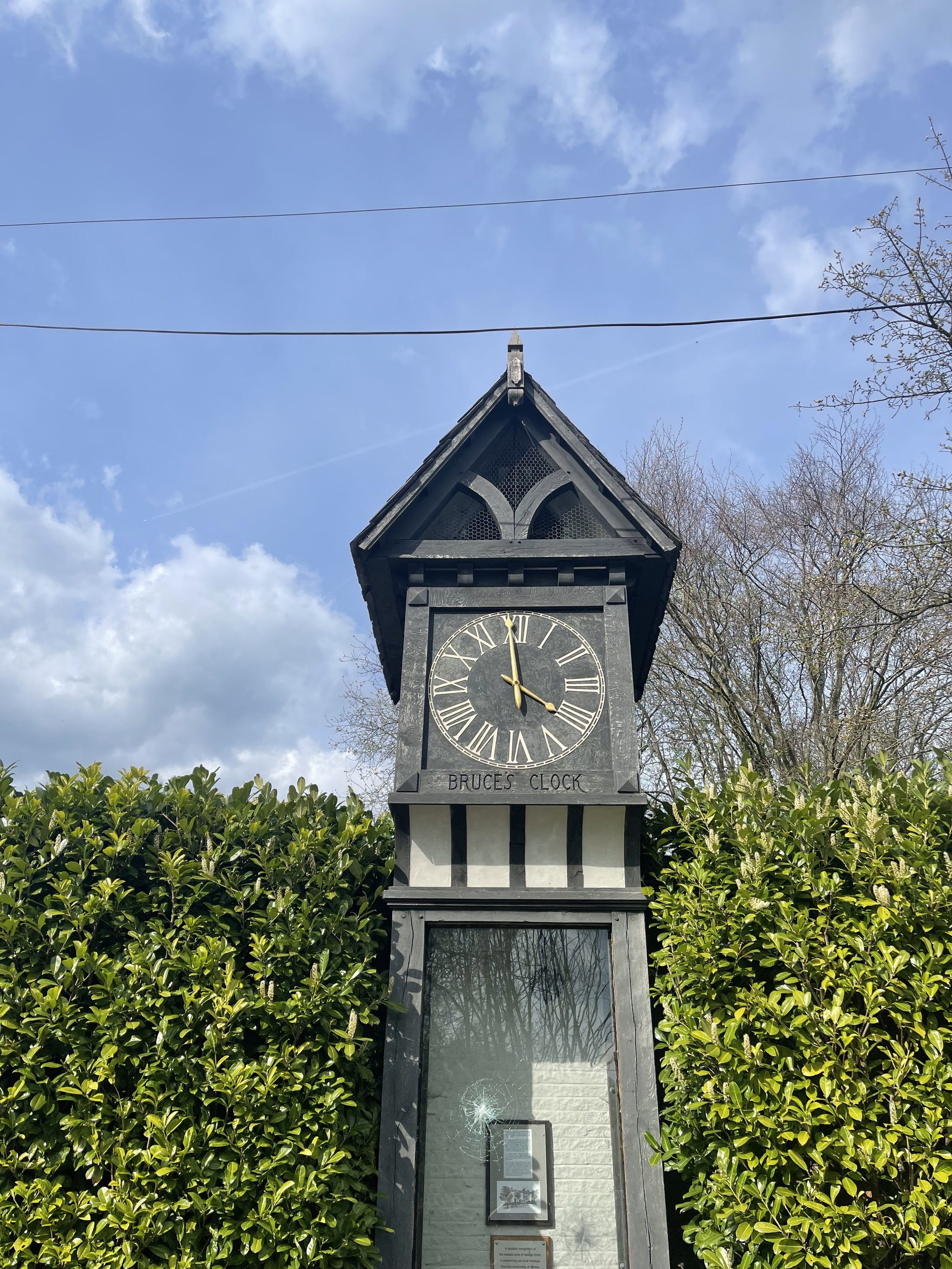
On the home stretch, the Goyt Way makes for a relaxing, flat stroll—taking you passed landmarks such as Bruce’s Clock in Strines. In medieval times, Strines stood as a large hunting forest—The Forest of the Peak—before local gentry settled here during the Elizabethan period.

Bruce’s Clock was originally found on the grounds surrounding Strines Hall, with the comings and goings of local people ordered by the striking of its bell in days when clocks and watches were rare household acquisitions.

After briefly meeting back up with The Roman Lakes footpath, you’ll finally reach The Peak Forest Canal to make the last stretch back to Marple.
The Waltzing Matilda sometimes moors here, so keep an eye out if you’re looking to refuel on woodfired pizza.

Looking for more walks like this one? Check out our adventures on Instagram
HATHERSAGE - FAIRY WOOD WALK
Seek some relief from the windy peaks and enjoy this short walk that’s perfect for a winter’s day…

Start: Oddfellows Road, Hathersage, S32 1DD
Distance: 4.63 miles
Duration: 2 hours
Elevation: 800 feet
Difficulty: Easy
Navigation: Download the GPX file here
Starting and ending in quaint Peak District village, Hathersage, this is a perfect route if you prefer your walks to start and end in a country pub or cosy cafe.
The route follows well-made paths up and out of the village, past the church, through beech woodlands, and up over the tops towards Stanage Edge, before meadnering back down into the village on country lanes.

Hathersage
This picturesque village in the Derbyshire Dales is adorned with stone cottages, a babbling brook, and welcoming faces aplenty. Take a moment to explore the local shops, cafés, and St Michael’s Church, where you can take a visit to Little John’s Grave.

A Legendary Wander: Discovering Little John’s Grave
Our walk leads you past St. Michael's Church at the start of the route, where you’ll find the final resting place of Little John, legendary companion to Robin Hood. If rich folklore and enchanted woodlands sounds like your idea of a great day out, this walk is for you.

Stanage Edge
Leaving the Fairy Wood behind, our route ascends towards the moors at the base of Stanage Edge. This iconic gritstone escarpment offers breathtaking panoramic views of the surrounding landscapes.

Good-to-knows
Facilities: Parking, Public Toilets, Cafes and Pubs
Parking: Parking is pay and display at Oddfellows Road, S31 1DD
Public Transport: Manchester Piccadilly > Hathersage, 56 mins.

Fancy giving this one a go? Follow the route here

LYME PARK > SPONDS HILL WALK
Blow away the winter cobwebs on this hidden gem of a local route…

Start: Lyme Park, Disley, Stockport, SK12 2NR
Distance: 6.83 miles
Elevation: 1,050 feet
Duration: 2-3 hours
Navigation: follow the route here
The Walk
If you’ve followed our walks for a while, chances are you’ll be well acquainted with the beauty of Lyme Park (we certainly talk about this local gem enough!). What may surprise you, though, is the extensive tapestry of untouched trails encircling Lyme that’re just waiting to be explored…
Having visited the Lyme estate many a time before, I couldn’t believe we’ve never taken a trip up to Sponds Hill. Despite clocking up just 1,050 feet of elevation, this route takes in quite a few trig points — so it’s a great one to explore if you’re not looking for something overly strenuous.

Amenities at Lyme Park
Lyme Park isn't just a starting point; it's a destination in itself. Before setting out on your walk, take some time to explore the estate. The mansion, surrounded by sprawling gardens, offers a glimpse into the area's rich history. If you fancy a bite to eat or a hot cup of coffee, the Timber Yard Café is the perfect spot to fuel up. There's also a shop where you can pick up intricate bits and bobs or essentials for your journey.
Admission Prices
See admission prices to Lyme Park below. Alternatively, you can start the route at Nelson’s Pit or extend the walk to find free roadside parking in Disley.
NT members: free
Adults: £6.00
Children: £3.00
Family: £16.50

Route Highlights
The Cage: As you leave Lyme Park, you'll pass by The Cage, a striking 18th-century hunting tower. Take a moment to admire the architecture and enjoy panoramic views of the surrounding countryside.
Bowstones: Continuing on your journey, you'll encounter the Bowstones – ancient standing stones that add a touch of mystique to the landscape. These stones have witnessed centuries of history and offer a great photo opportunity.
Sponds Hill: Finally, you'll reach the summit of Sponds Hill. The panoramic views from here are nothing short of spectacular, making the walk well worth the effort. Don't forget to bring your camera to capture the stunning vistas of the Cheshire Plain and beyond.
The Lantern: On your return, you’ll pass a deer leap in the wall, before arriving at another stile. Climb this stile and make your way along the path through the woodland. Eventually you will stumble across the Lantern (downhill on your left). Take some time to explore around the Lantern and take in the views down toward the house. Tradition has it that the top third of the Lantern used to be on the roof of the house where Minerva's statue now stands.

Transport Options:
Situated in Disley, Cheshire, Lyme Park is easily accessible by both car and public transport. If you're driving, ample parking is available on-site. For those relying on public transport, Disley train station is just a stone's throw away, providing a convenient option for those coming from Manchester or Stockport.

Fancy following along? Find full navigation details here

THE TRINNACLE: DOVE STONE LOOP
Fancy spending the weekend climbing Saddleworth’s most-snapped landmark? Then a scramble up The Trinnacle is a must…

Start: Binn Green Car Park, Oldham, OL3 7NN
Distance: 4.13 miles
Elevation: 950 feet
Duration: less than 2 hours
Navigation: follow along here

Fed up of the same old flat walking routes around the same old area?
Well, it turns out you don’t have to travel too far out of town to be transported to another world entirely…
Our route round Yeomen Hey Reservoir and up to The Trinnacle will have you feeling like you’re in a Canadian National Park, much less the outskirts of Ashton.

Located high on the hills of Saddleworth Moor, there stands a peculiar rock formation which has well and truly gripped the attention of ramblers far and wide.
Best known as ‘The Trinnacle’, this fork-shaped pillar juts out from the moorlands above Dovestone Reservoir and has attracted the attention of many keen photo opportunists as of late.

Made up of dazzling reservoirs, epic waterfalls, jaw-dropping scenery and steep inclines - alongside a couple of exhilirating scrambles along the river edge - this route really has it all.

Good-to-knows
Parking: Binn Green Car Park (RSPB). Please note, the spaces are limited and fill up quickly. We advise visiting off-peak where possible.
Public Transport: Catch the train to Greenfield Station. This extends the walk by about 50 mins each way.
Amenities: You’ll find an ice cream van and coffee truck at the base of Dove Stone Reservoir, with public toilets in the car park adjacent.
The Trinnacle: While this landmark certainly makes for a great photo opp, please only attempt scrambling if you are confident to do so. Make sure to take great care and only climb if the weather allows for it. The drop at the rear side is certainly no joke.
Fun fact: as we were climbing this one, a passerby shouted “I can’t watch! Make her get down!”, so make sure you have a head for heights whether you’re spectating or tackling it yourself.
Kit: Boots are ESSENTIAL for this one. The route is comprised of steep, slippery, boggy and rocky terrain. White trainer victims: be warned. (We certainly saw a few en-route!).
Take layers. It was a glorious day when we visited but remember where you are… layers are always a good idea.
Refreshments: Due to the idyllic Greenfield location, you’ll have your pick of pubs on this one. We recommend stopping off at The Roaches Lock, just a short drive away from the starting point.
Extending the route: Follow our extended 6 mile version here.
Fancy giving this one ago? Follow along here

SNAKE WOODLANDS LOOP
As magical Peak District walks go, Snake Woodlands is at the top of the list…

Start: Hope Woodland Car Park, S33 0AB
Distance: 3.59 miles
Duration: 1-2 hours
Elevation: 400 feet
Navigation: follow the route here

Easily missable as you drive along Snake’s Pass (A57), this magical wonderland is hidden from view until you venture down into the woodland adjacent.
This stunning pine forest landscape will have you feeling like you’re in the depths of a Canadian national park, much less on the outskirts of Glossop…

Surrounded by rolling hills, pine trees and babbling streams, you won’t be short on fairytale-like scenery on this short circular walk. In fact, this route has a mix of everything: magical woodlands, eerie moorland and even some spooky ruins to boot.

This route in itself is an absolute gem — but if you’re looking to get a few extra miles in, popular Peak District landmarks Higher Shelf Stones and the B52 Crash Site can easily be incorporated. You can follow our Crash Site walk here,

Due limited parking spaces, we advise going off-peak when you can. The good news is, you’ll usually have the place to yourself due to its hard-to-reach location.
Ready to be transported to your very own fairytale? Follow the route here

WINTER HILL AND RIVINGTON PIKE CIRCULAR
Enjoy this short ascent up to two iconic Lancashire landmarks

Start: Rivington Hall Car Park, Bolton, BL6 7SD
Distance: 6.15 miles
Duration: 2-3 hours
Elevation: 1,300 feet
Navigation: follow our route here
This Lancashire walk takes you to two incredible viewpoints in one route. You begin your ascent up to Winter Hill via Rivington Country Park, taking you 1,496 feet high up to the summit.
While there are a variety of routes to choose from, our favourite is this 6 mile walk which takes in arguable the best views and scenery across Bolton, Wigan and the West Pennines Moors.
After a brisk hike from Rivington Pike you'll soon approach Winter Hill, which reaches an elevation of 1,496 feet. The views from here are nothing short of breathtaking, especially during the winter months when the landscape is adorned with a pristine layer of snow. The panoramic vista extends as far as the eye can see, with the city of Manchester on one side and the rolling hills of Lancashire on the other.

What is Winter Hill?
After reaching the almost dystopian summit of Winter Hill, you may be left thinking “what on earth is this place?”. I know we certainly were.
While the reality of Winter Hill is a little less glamorous than my imagination led me to believe, the transmitting station is a working broadcasting and telecommunications site and is responsible for bringing you all your favourite local TV channels.

Rivington
Just over the border between Greater Manchester and Lancashire, Rivington is a magical landscape where mysterious ruins are nestled between magnificent reservoirs, moor tops and woodland aplenty.
It’s a place that’s packed with wholesome things to do, whether that’s exploring Rivington Terraced Gardens or going on an aerial adventure at Go Ape. The area is so stunning it was even dubbed "the Little Lake District” by the Victorians.

good-to-knows
amenities
The pike snack shack
You’ll pass this quaint little coffee shop at the base of Rivington Pike, offering a selection of hot and cold beverages and snacks.
Location: Rivington Pike Cottage, Horwich, Bolton, BL6 6RU
The Tea Room at Rivington
For a delightful cup of tea and some light bites, visit "The Tea Room at Rivington," nestled in a picturesque spot near Rivington Hall Barn.
Location: Rivington Hall Barn, Rivington Lane, Rivington, Bolton, BL6 7SB
The Rivington PUB and grill
Before or after your hike, stop by "The Rivington," a charming pub near Rivington Pike known for its cosy atmosphere and hearty fare.
Location: Rivington Lane, Horwich, Bolton, BL6 7SB
GO APE
Located close to Bolton and only 30-minutes from Manchester, Go Ape Rivington features exhilarating 13-metre-high platforms, beautiful country views and a zip wire over the reservoir.
Location: Great House Barn, Rivington, Horwich, BL6 7SB
Parking Options
Rivington Pike Car Park
Location: Rivington Pike Car Park, Rivington Lane, Horwich, Bolton, BL6 7SB
Public Transport
If you prefer or require to travel via public transport, you can reach Rivington Pike and Winter Hill by bus or train:
Bus:
The 125 and 575 bus routes have stops near Rivington Pike.
Check the latest bus schedules and routes to plan your journey.
Train:
Take a train to Horwich Parkway station.
From there, you can catch a bus or even walk to Rivington Pike.

Fancy giving it a go? Follow our route here

SK WOODLAND TOUR
A trail so idyllic it’s hard to believe you’re a literal stone’s throw away from the M60…

Start: Woodbank Park, SK1 4JR
Distance: 4 miles
Duration: 1.5 hours
Elevation: 225 feet
Navigation: follow the route here

Having lived in Greater Manchester most of our lives, it always amazes us when we stumble across new-found territory just a stone’s throw away from our old stomping grounds. This route that links up to Midshires Way and Alan Newton Way is one of them!
Named after Stockport’s Olympic medal-winning cyclist, The Alan Newton Way provides a safe off-road route from Marple to Stockport via the Goyt Valley and towards the town centre.

Expect quiet, old farm lanes, a forgotten hall and a wonderful little detour back through the Woodbank’s woodland. We stopped off at Chadkirk for a quick refuel and a wander around Marple Garden Centre. Starting the route from this end means you’ll be able to have a pitstop at Pear Mill’s Vintage Emporium - a must-visit for anyone yet to have a nosey.

To extend the route, you can follow the Way to Etherow Country Park, or join up with the Middlewood Way at Chadkirk.
For us, the highlight came in discovering Goyt Hall Farm, one of Stockport’s many small halls… but due to its remote location, one of the prettiest. This Grade II listed half timbered mansion-house was built around the same time as the popular Bramall Hall. Today, it’s a working farm and stables surrounded by gorgeous bluebell-dotted woods and fields.

LYME WOODLAND TO POYNTON COPPICE
Rich in wildlife, Chorlton Coppice is classed as an ancient woodland — leading visitors from the Middlewood Way into the heart of the coppice

Start: Lyme Park, SK12 2NR (Alternatively, you can complete the walk in reverse by parking for free at The Coppice)
Distance: 4.5 miles
Elevation: 575 feet
Duration: allow approx. 2 hours
Navigation: follow the walk step-by-step here

It’s not news that we love walks that link up with The Middlewood Way. With 11 miles of traffic-free paths, we love hopping on here whenever we visit Stockport-way for a little mooch.
We’ve passed Poynton Coppice a few times along the way — and after realising we could walk there from our other favourite landmark in this neck of the woods, Lyme Park, we knew we had to give it a go.

Our favourite part about this part of Greater Manchester are the many off-road transport links that link up with each other. On this particular journey to the Coppice, we walked along The Middlewood Way and The Macclesfield Canal — both offering great links across Stockport.

Poynton Coppice is pretty at any time of year, with swooping trees canopying your every move. Many areas of woodland across the UK are called ‘Coppice’, ‘Copse’ or ‘Copy’ from the French word ‘couper’, meaning 'to cut’.
Traditionally, coppicing provided a continual supply of wood — a traditional method of woodland management which involves cutting young tree stems to near ground level for optimal regrowth.

Fancy a mooch in the woods this weekend? Follow the walk here

STRETFORD MEADOWS
A scenic hideaway right on our doorstep…

Start: Hawthorn Lane, Chorlton
Distance: 7.03 miles
Duration: 2.5 hours
Elevation: 125 feet
Navigation: follow our route here

Looking for one of the best walks in South Manchester? Look no further…
Scenic views and wildlife might not be the first things that spring to mind when you think of Stretford, but that’s what makes this scenic spot just off the M60 so special.

One of the best short walks in Manchester, this route has it all: country lanes, a coffee pit stop and many links to extend the walk, including the Trans Pennine Trail.

While much of Stretford’s agricultural history has been lost to urban progression, this place is very much still teeming with wildlife. In the 19th century, Stretford was a hub for agriculture—known locally as Porkhampton due to the of pig farms which provided produce for the nearby Manchester Market. Wild, eh?

Back then, Streford was also an extensive market gardening area, described as the "garden of Lancashire" by writers of the time. In 1845, over 508 tons of vegetables were being produced each week for the Manchester Market, with their specialty being rhubarb—known locally then as “Streford beef”.
So successful was Stretford’s vegetable output, it became known as “ the Eden of Lancashire” throughout the Victorian era. In 1845, over 508 tons of vegetables were reported to be produced by Stretford market gardens for Manchester residents.

Pre-industrialisation, Romans named the area we now know as Stretford ‘Streta’—meaning street on a ford. Until the 1800s, the area existed as a cottage community dependent on hand-weaving, providing employment for almost 800 workers.

Our route takes you along a path which follows the line of the old Roman road from ‘’Deva Victrix’’ (Chester) to ‘’Mancunium’’ (Manchester), crossing the Mersey into Stretford at Crossford Bridge, a crossing point of the ancient ford.
Upon reaching the meadows, you’ll explore woodland paths, ponds and secluded spots which provide an ideal habitat for wildlife and a perfect place to unwind.

After a short stroll around the meadows, you’ll join the Trans Pennine Trail where you can enjoy panoramic views of the River Mersey. Along the way, you’ll pass Riverside Cafe, a gorgeous pop-up cafe selling hot drinks, sweet treats and homemade food.
For those looking to make a proper day of it, you can extend the route by heading to Old Ees Brook in Urmston, or by meeting up with one of the route’s many traffic-free transport links, including the Trans Pennine Trail or the Bridgewater Canal.

Fancy giving it a go? Follow the route here

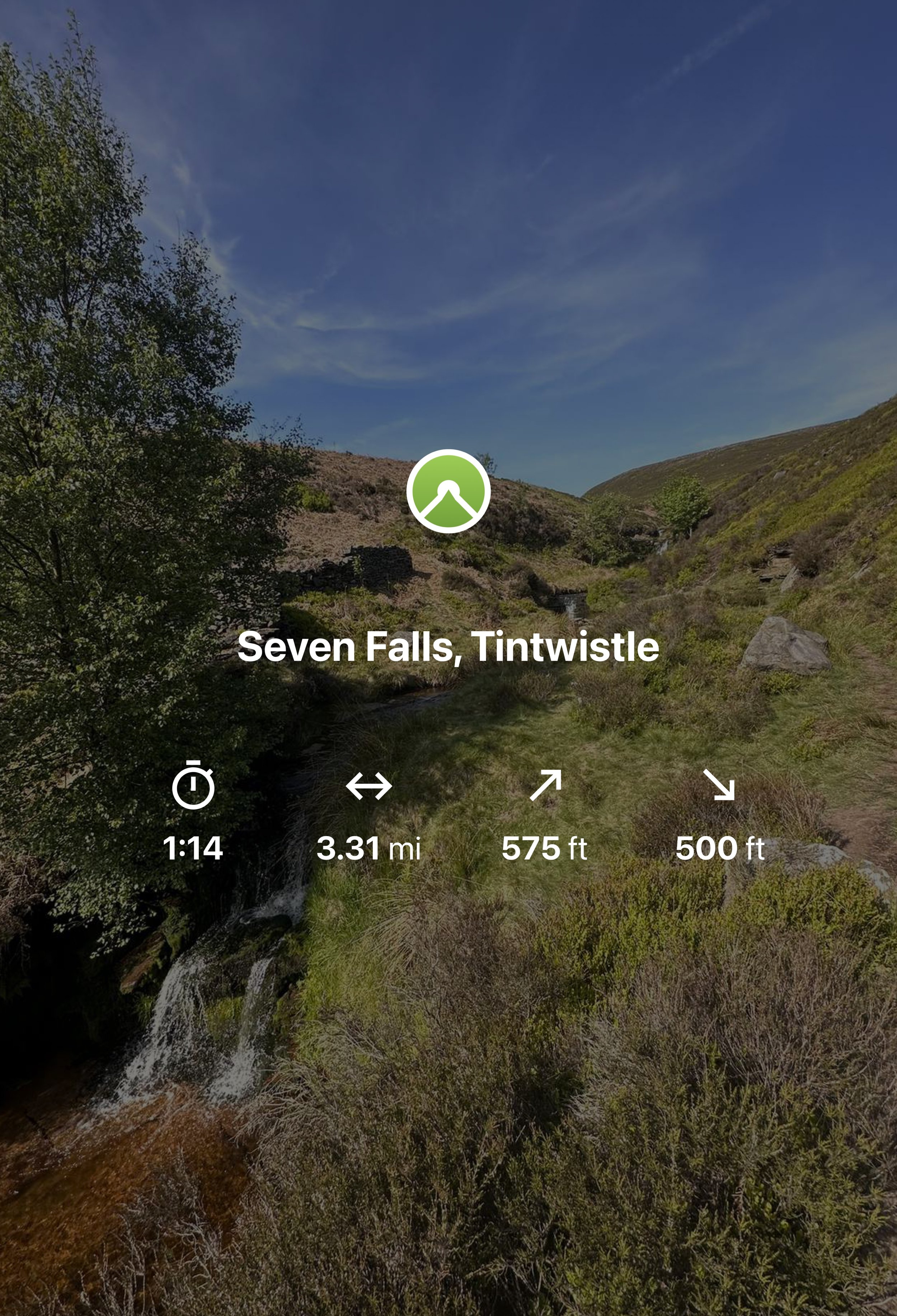
SEVEN FALLS SHORT WALK, TINTWISTLE
A short walk up to one of Greater Manchester’s (not so) hidden wild swimming spots

Start: Arnfield Fly Fishery, SK13 1HP
Distance: 3.31 miles
Elevation: 575 feet
Duration: Approx. 1.5 hours
Navigation: Follow the route here or download GPX file
Public Transport: Start the walk at Hadfield Station, with a mile walk to the start

The Peak District has a number of famous waterfalls within its boundaries that have become famous to walkers and and visitors to the area. Pretty Padley Gorge has a gentle cascading run of waterfalls along the course of Burbage Brook, Kinder Downfall, with a 30-metre drop is the tallest waterfall in the Peak District, and Three Shires Head, the meeting point of Cheshire, Derbyshire and Staffordshire is busy all year round.
But what about the less well known waterfalls in the National Park? One such place can be found in Tintwistle, an area north of Glossop on the western edge of the Peak District.
The area is well populated with several reservoirs which are great for walking but just to north of them runs Arnfield Brook which is the source of a series of cascading waterfalls and tranquil pool.
Let's dive in…
Arnfield Reservoir:

Our adventure starts at Arnfield Reservoir, a serene body of water offering a peaceful escape on the outskirts of Tintwistle and Glossop. Please note, parking here is limited, so arrive early to secure a spot. Take a moment to soak in the picturesque surroundings, grab yourself a cuppa or scan the restaurant and cafe’s menu for your post-walk treat on your return.
Arnfield Fly Fishery Cafe & Restaurant:

At the start of your hike, you'll encounter Arnfield Fly Cafe & Restaurant, a charming eatery nestled amidst the High Peak countryside. It's the perfect spot to refuel and recharge, with a selection of refreshments and delicious food to satisfy your cravings. Take a break, enjoy a cup of tea or coffee, and indulge in some delicious Thai food before continuing your journey towards the falls.
Seven Falls Waterfalls

Prepare to have your breath taken away as we arrive at the stunning Seven Falls waterfalls. While their location may no longer be a secret, it’s the perfect spot to cool off on a sunny Mancunian day. So if a wild dip is your ideal weekend pasttime, make sure to pack a cozzy because this is the ultimate wild swimming spot near Manchester.
Extend your adventure
Once you've soaked up the magic of the Seven Falls, consider extending your adventure by exploring some of the other scenic walks in the area.
Bottoms Reservoir: A leisurely stroll around Bottoms Reservoir offers peaceful surroundings and panoramic views. It's a perfect option for those seeking a shorter, more relaxed walk.
Higher Swineshaw Reservoir: For a slightly longer trek, venture to Higher Swineshaw Reservoir. This circular route treats you to breathtaking vistas and serene landscapes, making it an ideal choice for those craving more nature immersion.
Bottoms Reservoir to Dovestone Reservoir:
Start at Bottoms Reservoir and follow the trail that leads to Dovestone Reservoir. Take in the beauty of both reservoirs and the picturesque landscapes in between. The round trip is approximately 3.5 miles.
Greenfield Circular Walk:
Begin at Bottoms Reservoir and head east towards Greenfield. Explore the charming village and then return to the reservoir using a different path. This circular walk is about 4 miles in length.
Fancy giving this route ago? Follow along here
UPHILL CHALLENGES:


WALKS WITH WATERFALLS:


